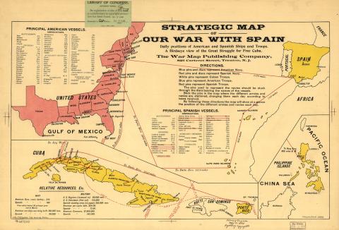
Strategic Map of Our War with Spain
Published in late May of 1898, this map proclaims itself to be “A Birdseye view of the Great Struggle for Free Cuba.” An incongruous composite, it shows the eastern half of the United States, Spain, and all three arenas of the War of 1898: Cuba, “Porto Rico,” and the Philippine Islands in the Pacific. The cartographer resolved the challenge of including the far-away Philippine archipelago by placing it in an inset over Africa. With the war still ongoing, the map also includes a full list of the U.S. and Spanish fleets. The Spanish vessels destroyed in Manila are crossed out to emphasize the enemy’s weakness.
This map was equipped with red, white, and blue pins that readers could move according to the daily news received. As if they had a war room at home, people used the map to track the progress of the military campaigns and strategize the next best moves.