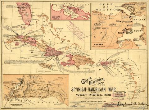
Goff's Historical Map of the Spanish-American War in the West Indies, 1898
Maps were among the most popular objects commercialized by the print industry during and after the War of 1898. Published in 1899, this one presents the Antilles, or the West Indies, as an arena of U.S. military victory. The southern part of Florida’s panhandle emphasizes the strategic proximity of these Caribbean islands to the United States.
Cuba and, to a lesser extent, Puerto Rico are the focus of the map, which provides highly detailed information on both islands. The names of harbors, towns, and cities, as well as U.S. Navy landing points, orient the viewer. A closer look reveals descriptions of U.S. military feats, such as bombarded towns and forced surrenders. Views of the Cuban bays of Havana and Santiago, as well as Puerto Rico’s San Juan Bay, reveal the starring role of the U.S. Navy in this war.